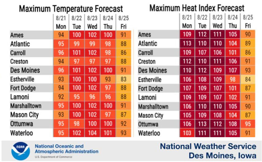
This could be the hottest week Iowans have endured in years, as near-record to record heat is likely. Forecasters say highs through Thursday will range from 95 to 105 degrees, with heat indices as high as 115.
If the forecast holds, National Weather Service meteorologist Andrew Ansorge says it will be the first time in a decade that August has had four or more consecutive days this hot in Des Moines. “And we’ve had that happen here where we’ve had periods of four or more days of 95 or higher 28 times in August since records began back in the late 1800s,” Ansorge says. Triple-digit temperatures are common in August, but he says highs are typically in the 80s by this late in the month.
Southern California was just hit with its first tropical storm in more than 80 years, though it was a hurricane in the Pacific Ocean for a while. Ansorge says that’s one of the reasons temperatures will be near or above 100 degrees in Iowa most of this week, as the low pressure system is pushing record-high heat from the Southwest to the Midwest. “Everything’s kind of interconnected and so even though we may not think too much about Hurricane Hilary there in the eastern Pacific,” he says, “it does kind of play a role, as do all the pressure patterns. They all work together in kind of moving things around the atmosphere.”
All of Iowa is under an excessive heat warning through at least Wednesday night, and relief may not come until Friday. The National Weather Service says this may be Iowa’s hottest string of consecutive days since 2013. The service predicts above-normal temperatures until September.
(By John Pemble, Iowa Public Radio)